
Hiking and Walking Trails
Hiking & Walking in Burlington
The Burlington Parks and Recreation Department would like to express our deepest thanks and appreciation to Alan Perrie who spent a tremendous amount of time developing the information for these trails, which will tremendously benefit the residents of Burlington.
Burlington is a great town to connect with the outdoors, because it has something for everyone. Its 6.1 miles of paved walking trails have Connecticut’s best views per mile. As a hiking town, it is in a class by itself. It has over 206 miles of hiking options on 47 different trail combinations. All were designed to be hiked using just one car. There are 33 Class 1 loop trails (155 miles) and 6 Class 2 loop hikes (50.6 miles). The Hike/Bike Loops provide a new experience on somewhat longer hikes that have you discover many new areas in Burlington’s forests. The mountain bike trails have very modest changes in elevation since they were designed to prevent erosion. They also have fewer trail markers, so you will need to develop the skill of following a well beaten path. They are somewhat wider and smoother than many hiking trails.
The great benefit of loop hikes is that you can double your hiking experience by hiking it in the opposite direction to see what was always behind you. Each group is listed with increasing difficulty, based on distance and elevation change. Clicking on the hike title gives a satellite map, trail, and parking directions. It is important to print out the one-page information link and bring it with you on the hike or have it on your cell phone. There are 2 major hike categories: Class 1 = hiking, but no climbing where hands need to be used. Class 2 = hiking and some climbing which requires the use of hands & careful foot placement. Distance is the one-way total in miles. Vertical feet is the total up and downhill. Hiking time is estimated without breaks. The Class 1 Tunxis Mainline Trail (25.4 miles) that can be shortened by using 2 cars. A short summary of hikes are listed below.
8 Class 1 Walks & Hikes for All Ages <3.5 miles: Distance, Vertical Feet, Time, Views
- Farmington River Trail: 1.0, 2.6, 3.5, or 6.1 miles, 0 - 20 feet, 95% river views
- Sessions Woods Forest Meadows Loop: 0.6 miles, 80ʼ vertical, 0.4 hours
- Brower Loop: 1.0 miles, 160' vertical, 0.5 hours, 3 views
- Sessions Woods Summer House Loop: 1.2 miles, 180ʼ vertical, 0.9 hours, 1 view
- Taine Mountain Double Loop: 3.0 miles, 860' Vertical, 1.7 hours, 1 view
- Perry’s Lookout Loop: 3.2 miles, 1,100ʼ vertical, 1.8 hours, 1 view
- Sessions Big & Little Loop: 3.2 miles, 645ʼ vertical, 1.2 - 2.0 hours, 1 view
- Sessions Highlight Loop: 3.4 miles, 675ʼ vertical, 1.3 - 2.0 hours, 2 views
14 Class 1 Hike/Bike Loops 3-5 miles: Distance, Vertical Feet, Hiking Time
- Hike/Bike: George Washington Crossing: 3.6 miles, 900’, 1.9 hours
- Hike/Bike: Kitchen Hallway: 3.8 miles, 800’, 2.0 hours
- Hike/Bike: Reservoir Ridge: 3.9 miles, 670’, 2.0 hours
- Hike/Bike: Stoney Hill Loops: 3.7 miles, 720’, 1.9 hours
- Hike/Bike: Patriot Trail: 4.2 miles, 860’, 2.0 hours
- Hike/Bike: Long Esker Trail: 4.6 miles, 910', 2.2 hours
- Hike/Bike: Long Wall: 4.6 miles, 960', 2.2 hours
- Hike/Bike: Green Mixmaster: 4.7 miles, 860’, 2.2 hours
- Hike/Bike: Highland Trail: 5.7 miles, 1,250’, 3.1 hours
- Hike/Bike: Adventure Trail 101: 3.6 miles, 770’, 1.9 hours
- Hike/Bike: Adventure Trail 102: 3.3 miles, 460’, 1.9 hours
- Hike/Bike: Adventure Trail 201: 4.4 miles, 600’, 2.3 hours
- Hike/Bike: Miller Time: 5.4 miles, 1.170', 2.4 hours
- Hike/Bike: Purple Boomerang: 5.5 miles, 910', 2.5 hours
12 Class 1 Loop Hikes >2.2 miles: Distance, Vertical Feet, Hiking Time, Views
- The Green Mile: 2.2 miles, 490' vertical, 1.2 hours
- The Discover Loop: 2.7 miles, 370' vertical, 1.8 hours
- Blue Orange Loop: 3.4 miles, 670ʼ vertical, 1.3 - 2.1 hours
- Wildcat Mountain: 3.2 miles, 1,450' vertical, 2 hours, 1 view
- Double Sessions: 3.9 miles, 810' vertical, 2 hrs, 1 view
- Devils Kitchen Loop: 3.9 miles, 1,130ʼ vertical, 1.7 - 2.7 hours
- Punch Brook Loop: 4.0 miles, 900ʼ vertical, 1.5 - 2.5 hours
- Mega Esker Trail: 5.0 miles, 1,000' vertical, 2.5 hours, 1 view
- Blue Green Loop: 5.5 miles, 1,520ʼ vertical, 3 hours
- GAP Loop: 5.6 miles, 1,500ʼ vertical, 2.0 - 3.0 hours
- Figure 8 Loop: 6.4 miles, 1,660ʼ vertical, 2.5 - 3.5 hours
- Big Loop: 10.4 miles, 2,040ʼ vertical, 4 - 5.2 hours
6 Class 2 Loop Hikes
- Great Wall: 5.6 or 4.3 miles, 1100ʼ or 900ʼ vertical, 2.9 - 3 or 1.8 - 2.1 hours
- Mile of Ledges: 3.1 miles, 750ʼ vertical, 1.7 - 2.9 hours
- The Long Loop: 9.4 miles, 2,300ʼ vertical, 3.7 - 5 hours
- The Grand Loop: 12.2 miles, 2,650ʼ vertical, 5.3 - 6.5 hours, 2 Class 2 sections
- The Mega Loop: 16 miles 4,000ʼ, 8 - 9.5 hours, 2 Class 2 sections
3 Class 1 "Out and Back" Tunxis Trail Hikes (a 2 car shuttle option reduces the miles by half)
- Tunxis Trail South: 8.8 miles, 2,160ʼ vertical, 4.5 - 5.6 hours
- Tunxis Trail Center: 7.8 miles, 2,160ʼ vertical, 4 hours
- Tunxis Trail North: 8.8 miles, 1,940ʼ vertical, 4.5 - 5.5 hours
Johnnycake Mountain Park
Connecticut Forest and Park Association will be doing a sizable trail relocation around the junction of the Blue / White and Blue / Green Trail over the summer of 2023. Hikers this summer might want to avoid these trails: Green Mile, Blue Green Loop, GAP Loop, and Long Loop.
Kudos to the NEMBA bike trail team for adding new plastic white diamond trail markers at junctions with hiking trail so that it is much easier to identify the bike from the hiking trails. White has always been the base color for bike trails. The original White Trail, created in 2013, is starting to get a fresh coat of white paint. The other bike trails are now being identified with two plastic diamonds: a white diamond on the top & colored diamond below. Some diamonds have arrows to point out trail direction. NEMBA has also been replacing some bridges to make it safer for everyone.
It is important for hikers to respect the NEMBA trails by not taking short cuts that could create erosion issues and make their blazed trail harder to follow. I also think it is a good idea for hikers to step off their trail and let any bikers pass. It is a great when hikers and bikers share positive experiences in Burlington’s forests.
Kudos to the new hiking trail crew: Almost all of the Blue Trails in town have new brightly colored blue rectangle blazes. New trail signs are now found at most trail junctions and road crossings. There have been some rerouting of trails to avoid erosion issues on steeper sections of the original trail. They have added board walks on long muddy trail sections and stepping stones at small stream crossings. They are also enhancing the hiking experience by avoiding long road walks. To appreciate the trail crew's incredible engineering skills you need to discover Burlington’s Big Bridge over Whigville Brook. I believe this 38 foot bridge could be the biggest on the Blue Trail system. Take a hike on the Blue Orange Loop to experience this bridge and the new trail construction skills. At this site, you will also discover an earthen dam built in the 1800’s.
The other new addition at all Blue Trail junctions are blue signs from the Connecticut Forest and Park Association saying that these trails are only for foot travel and are not to be used by bikes, horses, or vehicles. This policy can be found in the 2017 Connecticut Walk Book when they became concerned about erosion issues on the Blue Trail System. Many of the Blue Trails in Burlington is on land owned by the New Britain or Bristol Water Department. CFPA wants to avoid creating any water quality issues that might close the trails, which is why the new FOOT TRAVEL ONLY blue signs were added.
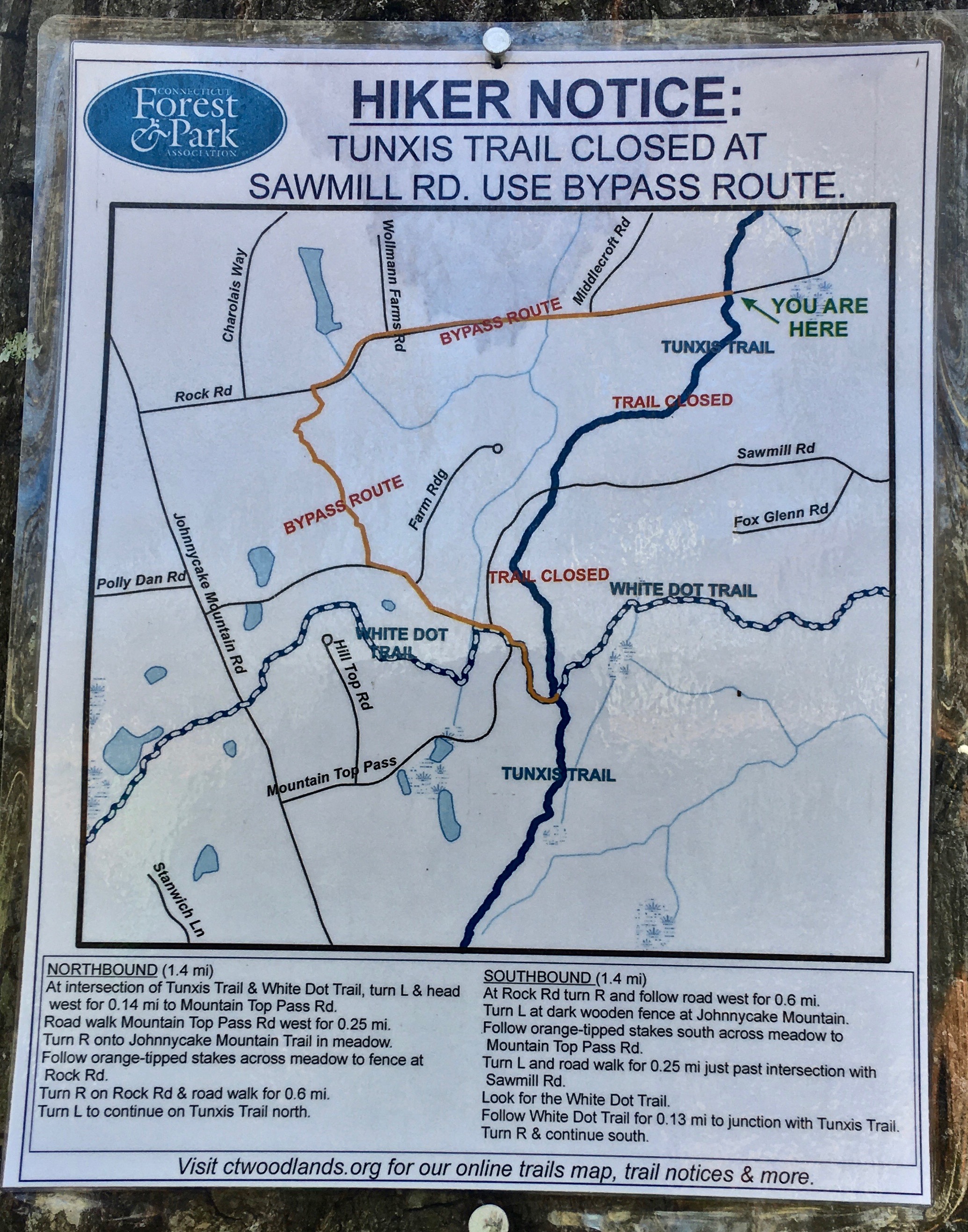
The Center section of the Tunxis Trail hike is now open using a bypass through Johnnycake Mountain Park. The Tunxis Trail Center hike will now be 7.8 miles long with 2,160’ vertical. Click this link for a map of the bypass and text directions going north or south: https://www.burlingtonct.us/sites/g/files/vyhlif2881/f/uploads/tunxis_bypass.jpg
A forest thinning operation is occurring on the east side of Stone Road. It is designed to improve the health and productivity of the remaining forest, as well as improve habitat diversity. The Blue / Red Trail remains open for hiking.
There are many trail crossings and some are not marked. It is important to bring along the above map and trail descriptions to keep you on track. A double blue blaze means a turn is very close. When the upper blaze shifts to the left, turn left. When it shifts to right, turn right. A single blue blaze means continue straight. The mountain bike trails are now using white plastic diamonds with an arrow to indicate direction. If you don’t see any blaze after a few minutes of hiking, you should backtrack to your last blaze to be sure you didn’t miss a turn found in the directions. The only exception to the blue or white blazes are on 2 properties managed by the Burlington Land Trust, which use a solid red or orange blaze. Not all streams have bridges. If the water appears too high for a safe crossing, come back another day.
Cumulative mileage to key features or trail junctions is found on the trail descriptions. To estimate distance, if you don't have a GPS, figure hiking speed to be 2 mph (a half mile every 15 minutes). Use your watch to estimate the time to the next trail junction. Be sure to tell someone your hiking plans and an estimated time of completion, which is found on the information link. A cell phone and a compass is important to carry. (Many cell phones have a compass). A daypack can be helpful to carry extra layers, rain gear, water, snacks, flashlight, cell phone, and trail directions.
Good trail etiquette preserves a positive experience for everyone in the future. Please carry out everything you bring in. Don't pick vegetation, disturb wildlife, or light camp fires during your hike. Stay on the established trails because short cuts create erosion problems. If you carry out other people's trash, you can earn bonus Karma points.
Parking for each hike is given by street location, plus latitude and longitude. Try the following example for Sessions Woods using www.google.com/maps. paste 41.732830, -72.955389 into the search box instead of an address, then zoom in using the satellite mode. You will be within 10 feet of the flagpole at Sessions Woods.
A very good resource is the Connecticut Walk Book, 20th edition. The introduction should be read if you are new to hiking the Blue Trail System. They also have the link to the Blue Trails Interactive Map at the bottom of this website: https://www.ctwoodlands.org/blue-blazed-hiking-trails/ blue-blazed-
Another good resource is the map to Sessions Woods: https://friendsctstateparks.org/wp-content/uploads/2017/08/Sessions-Woods.pdf If you visit Sessions Woods mid week, you must visit the nature displays in the main building. Sessions Woods combines education and recreation into a complete package.
A good New England Mountain Bike Association trail map that shows elevation is Trailforks: www.trailforks.com/map/?activitytype=1&z=14.0&lat=41.74995&lon=-72.95840